Archivo:Noel 01 nov 2007 1815Z.jpg

Archivo original (5600 × 7200 píxeles; tamaño de archivo: 5,75 MB; tipo MIME: image/jpeg)
| Éste es un fichero de Wikimedia Commons, un depósito de contenido libre hospedado por la Fundación Wikimedia. Más abajo se reproduce su página de descripción con la información sobre su origen y licencia. |
Resumen
| Descripción |
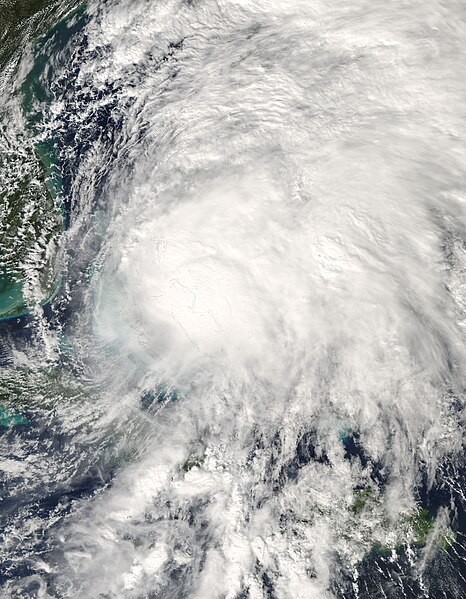
The Moderate Resolution Imaging Spectroradiometer (MODIS) on NASA’s Aqua satellite captured this photo-like image of Tropical Storm Noel as the storm passed over the Bahamas Islands on November 1, 2007, at 2:15 p.m., local time. At that time, Noel had sustained winds of 95 kilometers per hour (65 miles per hour) and was moving northeast at 23 km/hr (14 mph), said the National Hurricane Center. The storm later intensified into a Category 1 hurricane and tracked north along the east coast of the United States. Noel spreads messily across hundreds of kilometers in this image. The center of the storm, a tightly concentrated mass of clouds, sits nearly directly over the Bahamas, while clusters of thunderstorms stretch north and east from the center. In its rampage across the Caribbean, Noel caused at least 115 deaths, primarily in the Dominican Republic and Haiti, reported the Associated Press on November 2. Though the storm was relatively weak, it moved slowly over the two nations, dumping as much as 550 millimeters (21 inches) of rain. (View a satellite-based rainfall map.) The heavy rain caused deadly flooding and mudslides. The large image provided above is at MODIS’ maximum resolution of 250 meters per pixel. The image is available in additional resolutions from the MODIS Rapid Response System. |
|||||
| Fecha | ||||||
| Fuente | http://earthobservatory.nasa.gov/NaturalHazards/natural_hazards_v2.php3?img_id=14606 | |||||
| Autor | Image courtesy Jeff Schmaltz, MODIS Rapid Response Team at NASA GSFC | |||||
| Permiso (Reutilización de este archivo) |
|
|||||
| Otras versiones |
|

.jpg)
Historial del archivo
Haz clic sobre una fecha y hora para ver el archivo tal como apareció en ese momento.
| Fecha y hora | Miniatura | Dimensiones | Usuario | Comentario | |
|---|---|---|---|---|---|
| actual | 14:23 2 nov 2007 | | 5600 × 7200 (5,75 MB) | Good kitty | == Summary == {{Information |Description=Tropical Storm Noel (16L) over the Bahamas, as seen by the MODIS instrument aboard NASA's Aqua satellite on November 1 at 1815Z. |Source=http://rapidfire.sci.gsfc.nasa.gov/gallery/?2007305-1101/Noel.A2007305.1815.2 |
Usos del archivo
La siguiente página usa este archivo:
Uso global del archivo
Las wikis siguientes utilizan este archivo:
- Uso en en.wikipedia.org
- Uso en es.wikipedia.org
- Uso en eu.wikipedia.org
- Uso en pt.wikipedia.org
- Uso en www.wikidata.org
- Uso en zh.wikipedia.org