Archivo:View of Earth showing the Arctic, Europe, and Asia.jpg

Archivo original (12 000 × 12 000 píxeles; tamaño de archivo: 36,77 MB; tipo MIME: image/jpeg)

Resumen

Descripción
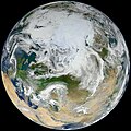
English: There have been many images of the full disc of Earth from space—a view often referred to as “the Blue Marble”—but few have looked quite like this. Using natural-color images from the Visible/Infrared Imaging Radiometer Suite (VIIRS) on the recently launched Suomi-NPP satellite, a NASA scientist has compiled a new view showing the Arctic and high latitudes.

Ocean scientist Norman Kuring of NASA’s Goddard Space Flight Center pieced together this composite image of Europe, Asia, North Africa, and the entire Arctic. It was compiled from 15 satellite passes made by Suomi-NPP on May 26, 2012. The spacecraft circles the Earth from pole to pole at an altitude of 824 kilometers (512 miles), so it takes multiple passes to gather enough data to show an entire hemisphere without gaps in the view.

Kuring stitched the image swaths together and then set up this view looking down from 70 degrees North, 60 degrees East. (That is, the view is artificial, as the satellite does not see the full disc at one time.) He was able to show the Arctic in this image because northern hemisphere spring spreads enough sunlight over the North Pole to allow a natural-light view.

VIIRS is a scanning radiometer that acquires data in 22 spectral bands, covering visible, near-infrared, and thermal infrared regions of the electromagnetic spectrum.
Fecha
Fuente https://oceancolor.gsfc.nasa.gov/gallery/404/
Autor NASA/NOAA. Image by Norman Kuring, NASA/GSFC/Suomi NPP. Caption by Michael Carlowicz. Suomi NPP is the result of a partnership between NASA, NOAA and the Department of Defense.

Licencia

Public domain Este archivo es de dominio público porque fue creado por la NASA. Las políticas sobre copyright de la NASA estipulan que «el material de la NASA no está protegido con copyright a menos que se indique lo contrario». (Políticas sobre copyright de la NASA o Políticas sobre la utilización de imágenes del Jet Propulsion Laboratory).
Advertencias:
  • El uso del logotipo de la NASA (incluidos el logotipo actual y los anteriores) está restringido.
  • El sitio web de la NASA almacena una gran cantidad de imágenes del Programa Espacial de la URSS, de la Agencia Espacial Federal Rusa y otras agencias espaciales no estadounidenses. Estas imágenes no son de dominio público.
  • Material del Telescopio espacial Hubble puede tener copyright si no proviene explícitamente del Space Telescope Science Institute. [1]
  • Todo el material creado por la sonda espacial SOHO está protegido por copyright y requiere permiso para ser utilizado con fines comerciales o no educativos. [2]
  • Las imágenes que figuran en el sitio web Astronomy Picture of the Day (APOD) pueden tener copyright. [3]
Public domain
Esta imagen es de dominio público porque contiene material que vino originalmente de la Administración Nacional Oceánica y Atmosférica de los Estados Unidos de América, recibidas o hechas en el curso de las funciones oficiales de un empleado.

العربية  čeština  Deutsch  Zazaki  English  español  eesti  suomi  français  hrvatski  magyar  italiano  日本語  한국어  македонски  മലയാളം  Plattdüütsch  Nederlands  polski  português  română  русский  sicilianu  slovenščina  Türkçe  Tiếng Việt  简体中文  繁體中文  +/−

Leyendas

Añade una explicación corta acerca de lo que representa este archivo

Elementos representados en este archivo

representa a

image/jpeg

Historial del archivo

Haz clic sobre una fecha y hora para ver el archivo tal como apareció en ese momento.

Fecha y horaMiniaturaDimensionesUsuarioComentario
actual03:12 26 sep 2023Miniatura de la versión del 03:12 26 sep 202312 000 × 12 000 (36,77 MB)Юрий Д.К.Uploaded a work by NASA/NOAA from https://oceancolor.gsfc.nasa.gov/gallery/404/ with UploadWizard

La siguiente página usa este archivo:

Uso global del archivo

Las wikis siguientes utilizan este archivo:

Metadatos